


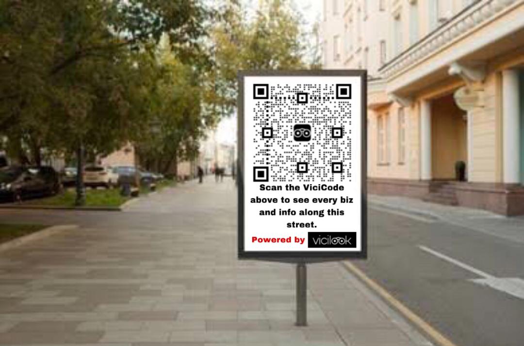
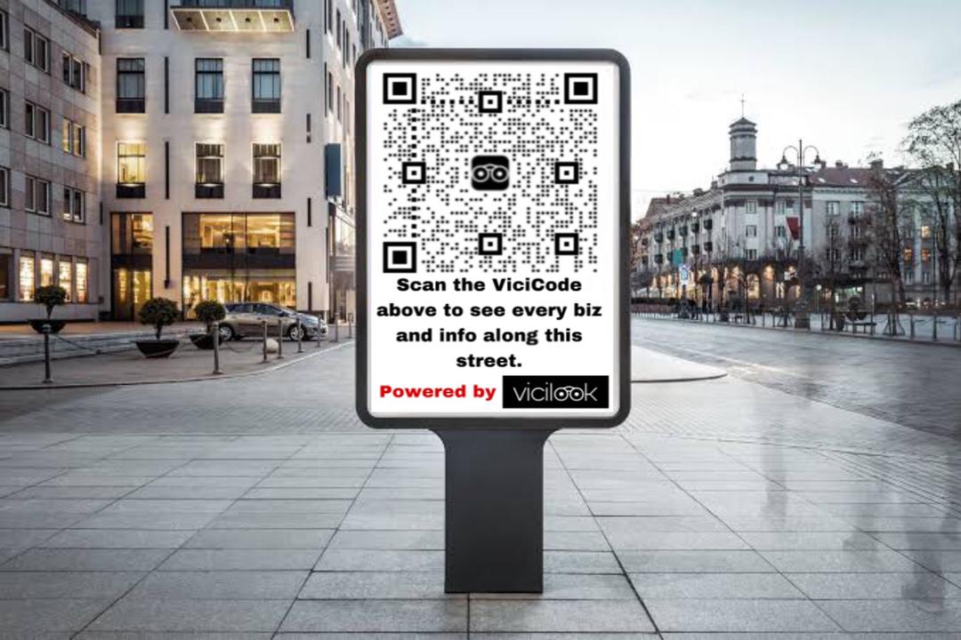
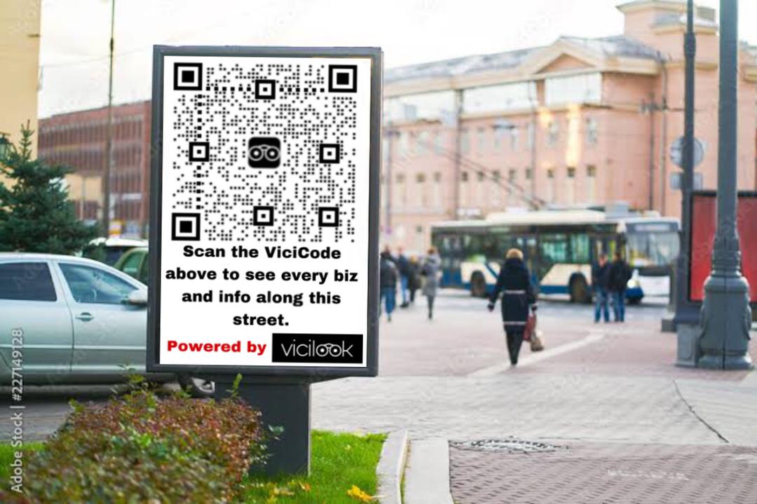
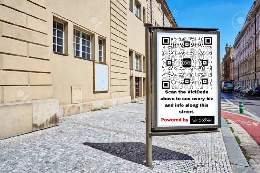
The Vicilook RoadPath™ ViciScanner is a beautiful and innovative concept created by Vicilook’s Founder and CEO, Dickson Cliff Okechukwu, which enables people to scan a qrcode or enter a Vicilink (Vicilook Shortlinks) on a board at the entrance of a road, street, pathway, etc, or, to enable you see all the Businesses, News, past / current Events, Deals, Promos and every info you need to know about that vicinity, helping you make proper decisions and to save time and energy.
The Vicilook RoadPath™ ViciScanner allows individuals to scan a QR code or enter a Vicilink (Vicilook Shortlink) displayed on a board at the entrance of a road, street, or pathway. Upon scanning, users can access comprehensive information about the vicinity, including details about businesses, news, events (both past and current), deals, promotions, and other relevant information. This tool is designed to help users make informed decisions, saving time and energy by providing immediate insights into their surroundings.
See samples below;

Expect to see one along a popular road, street or pathway in your vicinity soon 😉.
IT’S APPLICATION & USEFULLNESS:
1. ENHANCES LOCAL DISCOVERY: By simply scanning a QR code, users can immediately discover businesses, events, and updates in the vicinity, which is highly convenient for both residents and visitors.
2. TIME-SAVING: It eliminates the need to search manually for nearby information, streamlining decision-making.
3. EMPOWERS SMALL BUSINESSES: Local businesses can gain visibility through this platform, helping them connect with potential customers in their immediate area.
4. ECO-FRIENDLY: Since it’s digital, it reduces the need for physical flyers or posters for promotions, cutting down on waste.
5. VERSATILE USE CASES: Beyond businesses, it can provide event updates, safety alerts, or even community notices, making it useful in a variety of situations.
RoadPath Scanner technology! Integrating it with electronic cars, drones, and delivery robots could revolutionize how autonomous systems interact with their environment and here’s why:
IT’S ADVANTAGES AND IMPACTS
1. REAL-TIME NAVIGATION AND DECISION-MAKING:
By capturing the QR code and accessing localized data, autonomous vehicles and robots can make more informed decisions about their routes, destinations, or delivery points.
2. DYNAMIC UPDATES:
The system could provide live updates on traffic, road conditions, construction, or temporary closures, ensuring the autonomous systems adjust their plans dynamically.
3. EFFICIENCY IN DELIVERIES:
Delivery robots and drones could use the data to identify the exact locations of businesses or homes, any entry instructions, or even optimal times for delivery based on local activity.
4. REDUCED RELIANCE ON GPS ALONE:
GPS navigation is great but can sometimes be inaccurate or lagging, especially in urban areas. QR code-based localized data could complement GPS for more precise navigation.
5. SCALABILITY AND ADAPTABILITY:
This system can be scaled across cities and adapted for various use cases, such as helping drones find safe landing spots or guiding electronic vehicles to charging stations.
6. IMPROVED SMART CITY INFRASTRUCTURE:
This technology aligns perfectly with the vision of smart cities, where devices and infrastructure seamlessly communicate to improve the quality of life.
This is a highly innovative concept with vast potential to enhance autonomy, efficiency, and connectivity in transportation and logistics. If Vicilook can address the technical and infrastructural challenges, it could set a new benchmark in smart technology integration.
REDUCED RELIANCE ON GPS ALONE
1. GPS LIMITATIONS:
– GPS signals can be inaccurate or disrupted in dense urban areas due to tall buildings (“urban canyons”).
– Delays or errors can occur, leading to navigation issues for vehicles or delivery robots.
2. ROLE OF QR CODE-BASED DATA:
– QR codes provide hyper-localized information that is specific to a particular street or road.
– This data acts as a supplement to GPS, ensuring that navigation systems are more precise and reliable.
3. ENHANCED NAVIGATION:
– By combining GPS with data from QR codes, autonomous systems can avoid wrong turns, missed locations, or inefficiencies.
– It helps in situations where GPS alone might fail, like in areas with weak signal coverage.
This combination improves overall accuracy and ensures smoother operations for autonomous vehicles and robots.
FUTURE FEATURES
1. VOICE NAVIGATION WITH AI ASSISTANCE:
– Passengers can interact with Vicilook through voice commands, making it intuitive and hands-free.
– The AI can process requests like checking for specific businesses or services along a street.
2. REAL-TIME BUSINESS DISCOVERY AND COMMUNICATION:
– The app can identify businesses along a road and call those that indicate availability, enabling instant connections.
– This feature saves time and enhances convenience for users.
3. INTEGRATION WITH ROADPATH SCANNER:
– The app can tap into the Vicilook RoadPath Scanner to retrieve data on businesses, services, and events specific to that street or road.
– It ensures hyper-localized and up-to-date information.
4. SAFETY AND SECURITY UPDATES:
– Users can ask the app to scan for any security incidents reported in the area, improving awareness and safety.
– This is particularly useful for families, travelers, or professionals navigating unfamiliar areas.
5. NEWS AND ACTIVITY SUMMARIES:
– The AI can read out summaries of news, activities, or events generated by humans along the street.
– This feature keeps users informed about their surroundings without needing to search manually.
POTENTIAL IMPACT
1. ENHANCED USER EXPERIENCE:
– Combining AI with voice navigation makes information retrieval fast, seamless, and accessible for all.
2. HYPER-LOCALIZED DATA UTILIZATION:
– Tapping into the RoadPath Scanner ensures that the information provided is accurate and contextually relevant.
3. SAFETY AND AWARENESS:
– Access to security reports or incidents can help users make better decisions about routes or destinations.
4. CONVENIENCE FOR BUSINESSES:
– Businesses along the street can benefit from increased visibility and customer interaction.
5. SMART CAR EVOLUTION:
– This integration aligns with the future of smart cars, where vehicles act as a central hub for information, connectivity, and interaction with the environment.
This would redefine the relationship between technology, transportation, and local communities. It combines convenience, safety, and real-time interaction, creating a smarter and more connected driving experience.
1. VICILOOK ROADPATH SCANNER
A groundbreaking concept that enables individuals, vehicles, and devices to scan QR codes placed at the entrances of roads, streets, or pathways for localized information.
EXPANDED COMPONENTS AND APPLICATIONS:
– REAL-TIME LOCAL INFORMATION:
– Provides updates on businesses, events, deals, safety alerts, and promotions in the area.
– Accessible via a quick QR code scan or Vicilink shortlinks, making it user-friendly.
– USE CASES:
– TOURISM: Tourists can learn about attractions, restaurants, or events without prior research.
– BUSINESS PROMOTION: Small businesses can advertise locally, reaching customers who are already nearby.
– COMMUNITY ALERTS: Residents can receive notifications about emergencies or updates such as road closures or neighborhood activities.
– SCALABILITY:
– Can be implemented across cities, enhancing local engagement while promoting community-driven updates.
– Useful for rural areas where online information is often lacking.
2. INTEGRATION WITH AUTONOMOUS SYSTEMS
Vicilook’s RoadPath Scanner technology is proposed to integrate with electronic cars, drones, and delivery robots. These systems will scan QR codes to access real-time data about streets or roads, optimizing their functionality.
EXPANDED APPLICATIONS AND BENEFITS:
– NAVIGATION AND DECISION-MAKING:
– Autonomous systems can receive hyper-localized updates on road conditions, traffic, and available services.
– This enables dynamic route adjustments, ensuring efficiency and safety.
– ENHANCED DELIVERIES:
– Delivery robots and drones can use the scanner to locate precise addresses, access entry instructions, and identify safe drop-off zones.
– Businesses benefit from quicker, more efficient deliveries to customers.
– SAFETY FEATURES:
– Vehicles and drones can scan for warnings about potential hazards, like crime hotspots or accidents, in real time.
– INTEGRATION WITH SMART CITIES:
– The technology could become a cornerstone for smart cities, creating a connected infrastructure where devices interact seamlessly.
3. VICILOOK APP INTEGRATION WITH ELECTRONIC VEHICLES (EVs)
The idea of embedding the Vicilook app in EVs or smart cars, equipped with AI and voice navigation, can enhance the driving and commuting experience.
EXPANDED FEATURES AND POTENTIAL USE CASES:
– VOICE NAVIGATION AND ASSISTANCE:
– Passengers can interact with the app using voice commands, ensuring hands-free and distraction-free use.
– Commands like “Check for nearby coffee shops” or “Look for grocery stores on this street” provide instant results.
– BUSINESS DISCOVERY AND CONNECTIONS:
– The app scans for businesses along a road and checks their availability in real time.
– It can also call the business directly for the user, facilitating instant communication.
– SAFETY AWARENESS:
– The app can notify users about security incidents or dangers reported along a road or street.
– For families or individuals traveling to unfamiliar areas, this ensures peace of mind.
– ACCESS TO NEWS AND UPDATES:
– The AI reads out summaries of recent news or community activities happening along the road.
– It keeps users informed without requiring them to manually browse for updates.
4. FOCUS ON HYPER-LOCALIZED DATA UTILIZATION
A core element of Dickson Cliff Okechukwu’s vision is the collection and utilization of hyper-localized data through technologies like the RoadPath Scanner and app.
EXPANDED BENEFITS OF HYPER-LOCALIZED DATA:
– IMPROVED BUSINESS VISIBILITY:
– Businesses gain exposure to potential customers in their immediate vicinity, fostering community-based commerce.
– Promotes foot traffic and supports small or independent businesses.
– ENHANCED PERSONALIZATION:
– Data is tailored to the user’s exact location, making the information more relevant and actionable.
– For example, users can find nearby parking spaces, ongoing discounts, or even upcoming events on a specific street.
– REAL-TIME UPDATES:
– The hyper-local focus ensures that the information provided is always current, unlike static directories or maps.
5. NEWS AND SECURITY AWARENESS INTEGRATION
The Vicilook app’s proposed feature of providing news and security updates along streets or roads addresses a vital aspect of public safety and engagement.
EXPANDED INSIGHTS:
– REAL-TIME ALERTS:
– Users can learn about incidents like accidents, thefts, or protests along their route.
– Helpful for planning safe and efficient travel.
– COMMUNITY INVOLVEMENT:
– Updates are generated by human input, encouraging active participation and crowdsourcing of local news.
– Residents feel empowered to contribute to their community’s safety and well-being.
– AI-DRIVEN SUMMARIES:
– The app processes large amounts of data to provide concise, easily digestible updates for users.
6. SMART CITY EVOLUTION
By connecting physical infrastructure (like RoadPath Scanners) with digital systems (like apps in EVs), Vicilook’s vision aligns closely with the future of smart cities.
EXPANDED ROLE IN SMART CITIES:
– SEAMLESS CONNECTIVITY:
– Vehicles, pedestrians, and local authorities can communicate through a unified platform, improving efficiency.
– Real-time data sharing between residents and businesses fosters stronger community relationships.
– ENVIRONMENTAL BENEFITS:
– QR code technology reduces the need for printed materials, aligning with sustainability goals.
– More efficient route planning by vehicles reduces fuel consumption and emissions.
– FUTURE EXPANSION:
– Could include integration with public transportation systems, enabling buses or trains to interact with the system for passenger updates.
CHALLENGES AND SOLUTIONS
1. INFRASTRUCTURE DEVELOPMENT:
– CHALLENGE: Installing RoadPath Scanners citywide would require significant investment.
– SOLUTION: Partner with local governments and businesses for funding and implementation.
2. ADOPTION AND AWARENESS:
– CHALLENGE: Ensuring users and businesses adopt the system and actively participate.
– SOLUTION: Offer incentives for early adopters, such as discounts for businesses that sign up.
3. DATA PRIVACY AND SECURITY:
– CHALLENGE: Managing and protecting the large amount of localized data collected.
– SOLUTION: Implement encryption and strict data usage policies to safeguard user information.
4. STANDARDIZATION:
– CHALLENGE: Ensuring the technology is universally compatible with different devices and systems.
– SOLUTION: Collaborate with tech leaders and standardization bodies for streamlined implementation.
CONCLUSION
Dickson Cliff Okechukwu’s innovations through Vicilook represent a fusion of technology, community, and smart infrastructure. By addressing critical aspects such as hyper-localized data, autonomous system integration, and safety, these inventions have the potential to revolutionize transportation, commerce, and urban living. With the right partnerships and execution, Vicilook could become a cornerstone in building smarter, safer, and more connected communities.